by Larry Anglisano
Judging by the e-mail we get, some owners are on a never-ending search for the ultimate portable navigator and in the process, many a would-be buyer overthinks the selection criteria. Our impression is that some buyers fret about having too many features while others worry about coming up short.
In our view, display readability is near the top of the list of must-haves when shopping the portable navigator market. And after flight testing the AvMap EKP III C, we think its the no-contest winner in this category, even if it otherwise has a wart or two.
Familiar Design
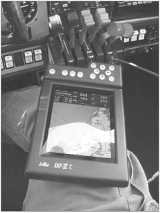
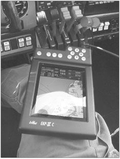
Havent you seen this somewhere before? Yes, you have. The unit harks back to the early days of the Magellan EC10 series, which C-Map helped develop. The EKP III C is a direct descendent, having matured from the original EC10X portable, the first high-detail aviation moving map. The GPS/display combo is big and robust, weighing in at 1.8 pounds and measuring 6 X 2.6 X 9.4 inches.
But this large size isn’t necessarily a bad thing because the navigator is designed to function as an electronic knee board, with insets for your leg molded on the bottom of the case, which straps on with a durable Velcro leg strap. The unit can also mount with multiple RAM Mount accessories.
Were accustomed to flying with a kneeboard so the navigator was comfortable to strap to the right leg as we ventured on a four-hour trip from Hartford to South Carolina.
When we unpacked the product, we immediately didnt like the controls at the top of the case, above the display. It occurred to us that button pushing would block the view of the display but in real world ops, it didnt work out that way. So much for first impressions.
The screen is so large that pushing the buttons at the top of the bezel didnt obstruct the screen. What helps is that unit is intuitive to use, so cruising through menus is a snap; you get what you need quickly, without blocking the view with your hands.
The power key brings the navigator alive and controls brightness and contrast, near lists nearest objects, a simple and familiar GOTO key is for simple no nonsense direct navigation, the menu brings up the moving map page, the main event of the EKP III C and ESC backs you out of menus and rejects an action. There are also zoom in/out keys and an enter key to highlight and acknowledge things on the screen.
Onboard GPS
The internal GPS is a WAAS-enabled design that connects to an external antenna. We don’t know why some portable manufacturers insist on using thin 5 mm cable with SMB-type connectors but we always feel the stuff has to be treated tenderly and its very tangle prone.
The quick-disconnect hardware (antenna and power supply inputs) fit nicely into the forged ports in the IIICs case and the entire package feels solid, a refreshing change from the plastic crap weve grown accustomed to.
A version of the EKP III C is offered for tactical law enforcement applications (the EKP III C-Pro model) and it would at home in a military cockpit, in our estimation.
With the antenna placed, the navigator found itself and was ready for duty in a matter of minutes.
The display on the EKP III C is perhaps the best we have seen in a portable and can easily keep pace with the most expensive panel mounts. The color display is a 6.4-inch diagonal design with 640 X 480 pixel resolution that can be easily viewed in any lighting condition.
Using this device in the car was the ultimate test of the display, as we had it sitting on the passenger seat and at a high viewing angle. The display is so crisp and bright, that its easily visible from a distance and at high angles. But there’s a tradeoff: Heat.
Halfway through the trip to South Carolina, the III C was about to burn a hole through our cargo pants. If you had this unit strapped to your leg during the middle of summer ops in a non air-conditioned cockpit, youd be hard pressed to keep it there while wearing shorts.
The specs call for an upper operating temperature range of 131 degrees F and we don’t doubt it will get that warm.
For precise course navigation, an HSI screen with vertical situation indicator scale and course deviation indicator makes navigating a course and planning a descent an easy, highly visual process.
The VSI can be set to change the scale from 250, 500 and 1000 feet. Nav data can be customized in data fields at the top of the screen, which houses the nav data window. You can even orient the HSI compass presentation for north-up or track-up.
While this unit and all other portable navigators arent approved for primary navigation, it does have instrument approach procedure waypoints in its database and these can be used for flying a full approach in back-up mode.
You can access approach information directly from the moving map page by placing the cursor over the destination airport and pressing enter. Detailed airport information will be shown on screen and from there you can call up approaches for that airport.
Once an airport is active as a final waypoint in the flightplan, you can select from approaches for the airport, highlight the one you want and the waypoints will appear in your flightplan.
Once youre back to the mapping page, the waypoints for the approach will be shown as a flightplan on the map. Its an intuitive, well-thought-out operating logic, which we were impressed with. Some navigators-panel mounts included-make loading an approach a long and confusing event but the AvMap unit cuts right to the chase with minimal heads down time.
Deep Down
It seems that some navigators have in-depth functions that few of us ever use, such as average speeds and odometers. The EKP III C has a calculator menu that actually has useful information plus the usual data that most of us could take or leave.
The trip computer tracks data such as average speed (speed above 35 knots divided by flying time), overall average, maximum and minimum speed, flying time, stopped time, trip time, trip distance and a value called partial distance, which the book says means total distance since reset. (We don’t get that one.)
But we did get the vertical navigation function, which lives within the calculator menu. This feature pulls up a full screen vertical nav box that shows time to go, distance, descent rate, altitude to go if traffic pattern altitude for the destination exists in the database, plus a glideslope value to the descent waypoint. The checklist function (from engine start to landing) is also nifty but we wonder how many users might actually use it.
Conclusion
Considering a street price of $1595 for the color version and $895 for the monochrome version, we think the EKP III C is a worthy product in the high-end world of portable navigators. Whether it will be buried in the onslaught of GPS296s pouring out of the Garmin factory remains to be seen. This thing really is an unsung, under-marketed winner.
Its kneeboard design is unique and it works well, but you cant write on it so if youre accustomed to flying with a kneeboard for copying clearances and such, you’ll have to break your habit or get creative with a RAM mount.
We think this product is perfect for helicopter operations as its highly visible display is excellent for bright cockpits. The GPS performs we’ll and overall, the EKP III C is feature rich.
We just wish that it didnt get so darned hot. In our view, if C-Map could make a panel mount unit with a screen like this portable, it would be a grand slam home run; just don’t forget the cooling fan.
Contact – C-Map Aviation, 508-539-2817, www.c-map.com.
Also With This Article
“Checklist”
“Ops at a Glance”
-Larry Anglisano is Aviation Consumers avionics editor.


