268 In th
ASPEN says that the display can be expanded to encompass weather and storm avoidance. The face of the instrument houses a brilliant but small 2.5-inch color high-resolution active-matrix LCD display, sporting 240 x 480 pixels. The display is bright and clear

with automatic or manual dimming capability. We found the display perfect for mounting in the VSI position of any six-pack configuration of steam gauges and it has a reasonable side viewing angle, especially when splashed with sunlight in a medium-size cockpit.
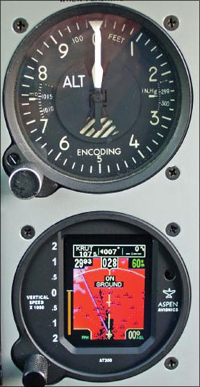
Rate of climb functionality, which is displayed on the left side of the display in vertical tape format, is driven by the aircraft static system just like any other mechanical VSI. Vertical speed rates of 2000 FPM are measured in major and minor tick marks on the screen. There’s also a numeric readout of FPM 9900 on the bottom left corner of the display. Vertical speed is displayed as two digits once you get moving quicker than 2000 FPM in either direction. For example, a 4600 FPM descent will read as -46 FPM. The thousands digit (4) is shown full size while the hundreds (6) is a smaller superscript digit.
In the unfortunate event that the aircraft vertical speed exceeds 10,000 FPM, the vertical tape display pegs and the digital readout goes to dashes, indicating that the game will likely soon be over. In most aircraft, the existing VSI static line can be retained and plumbed into the static fitting on the back of the AT300 case. A static system check and recertification must be done afterward to ensure system integrity.
Moving Map
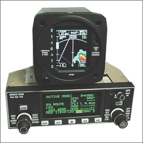
In addition to terrain functions, the AT300 provides a basic supplemental moving map display of GPS navigation information. An RS232 feed between virtually any general aviation panel-mounted GPS navigator allows the AT300 to display position, desired track, distance and estimated time to waypoint, the waypoint identifier and groundspeed. There’s even a bearing pointing arrow that pops up when the difference between the desired track and actual track exceeds 5 degrees.
All this data is focused in a navigation box at the top of the display. A magenta course line based on active waypoint from the GPS is overlaid across the screen, in track-up format. Non-active legs in the flight plan are white, and change to magenta when the next leg becomes hot.
The navigation and moving map capabilities of the AT300 are basic compared to most modern navigators, but its functionality when paired with an early-generation navigator mapless navigator like the Garmin GPS150 or Northstar M3 is terrific. Airports are depicted with a round blue-and-white airport icon. Once you scale the map beyond 60 miles, the airport symbols disappear in de-clutter mode.
The AT300 has interactive text messaging with text warnings appearing in the center of the screen. Such messages include “LANDING,” based upon distance to the airport, altitude and direction of flight. “LOW VOLTS” warns of electrical system demise and the fact that the system likely wont operate much longer. “ON GROUND” reminds you that your wheels have touched, while “DEPARTURE” lets you know youre airborne.
TAWS-like Terrain
The real purpose of the AT300 is terrain mapping and its operating logic puts it in a class of its own. A built-in terrain and obstruction database housed on a removable storage card on the side of the units case is responsible for terrain mapping the continental U.S. Fresh terrain data is released every six months. In our view, the ground doesnt change much, but manmade obstructions do, so we think database updates should be done regularly.
What makes the AT300 different is that it shows color-coded terrain relative to the surrounding altitude of the aircraft, based on the vertical separation between aircraft and terrain. This functionality is accomplished through aircraft barometric altitude data (through the static system) and by the pilot inputting the current baro-setting.
Its important to recognize that the same level of error found with mechanical altimeters and increased error during extreme cold temperatures will be trouble for the AT300. The usual death and destruction caveats of not using the AT300 for sole-means terrain avoidance apply here. For pilot correction of current altimeter settings, among other chores, the AT300 has a single push-and-twist control knob located on the lower left corner of the bezel. Pushing the knob moves the on-screen cursor from baro-setting to map scale adjustable between 5 and 100 miles at the upper right corner of the screen. Holding the knob in brings up the display dimming menu, for overriding the photocell-controlled brightness.
Rotating the knob to the left toggles between nav data and terrain profile view, at the top of the display. In the profile view, an aircraft icon on the left shows the aircraft in reference to rising peaks of terrain, a feature we really like on big displays such as the Garmin-AT MX20 and now the new GMX200. The AT300s control knob has a positive and rugged feel, which we applaud.
The most important field is located at the lower right corner of the display. It shows the approximate height above the ground, rounded to the nearest 100 feet. This field is active when the AT300 calculates the aircraft to be below 20,000 feet.
There’s also a field on the opposite side of the display that houses a variable tick mark that represents rising terrain. This electronic rising terrain bar is somewhat hidden as its partially overlaid on top of the VSI tape.
Nonetheless, as the aircraft descends closer to the ground, the rising terrain bar comes alive, first appearing once the aircraft height above the ground is 2000 feet AGL.
As the aircraft gets closer to the ground, the bar rises toward the zero tick mark on the VSI marking. Similarly, on departure, the bar shrinks slowly out of view in appropriate scale as the aircraft leaves the terrain below. This sounds intuitive and it really is; but it was tough for us to focus on the bar as we cleaned up the aircraft on a busy departure and transitioned enroute. For this reason, we feel the AT300 could really use a larger screen for more viewing area.Own-ship aircraft position in relation to the map and terrain is located at the bottom center of the display.
If it sounds like there’s a lot of data being displayed on one 2.5-inch screen, there is and the characters are small. The saving grace, however, is the crisp resolution of the display. We were able to see all the data without trouble while hiding behind polarized Ray-Bans.
Terrain Colors
Our flight test of the AT300 put us on top of a broken-to-overcast layer above 2300 feet MSL terrain. Remember, the AT300 depicts terrain in AGL so the transition from MSL to AGL takes a bit of getting used to.
The AT300 has multiple modes of operation: Ground/Landing/Departure mode and Enroute mode or normal operation. The system is in Enroute mode when not operating in the direct vicinity of an airport. If this Enroute condition is met, the system will map terrain profiles from 2500 feet below to 3500 feet above the aircraft. The AT300 terrain color coding requires study before blasting off, as we learned. In Enroute or Normal mode, if terrain is greater than 2500 feet below the aircraft, the screen is dark, showing no threat.
This is where our turboprop owner was disappointed we’ll get to that in our conclusion. Light green indicates that terrain is 2500 to 1500 feet below, dark green is 1500 feet to 500 feet below while terrain thats 500 feet to the same altitude as the aircraft is depicted in yellow. Red means the terrain is at the same altitude or 1500 feet above, so you had better pull up or turn to an area on the map that isn’t red.
We couldnt figure out why the display was painting a shade of blue, or cyan, as we pointed the nose toward the east. Turns out that cyan means the area is out of the terrain mapping boundary, such as over water, which was where we were pointed. As long as we kept up with setting the proper baro-setting, the AT300 painted the terrain below with accuracy as we step descended closer and closer to the rocks below.
Our test aircraft was equipped with a Garmin GNS430 with the advisory terrain base map and terrain database and compared to the AT300, it was nearly useless in our view. It switched to its dedicated terrain page, turned red and told us to pull up as we got close enough to terrain, just like its supposed to do. But it doesnt come close to the terrain mapping of the AT300. The unit appropriately and accurately depicted a couple of 1300-foot towers as we got close, as did the GNS430.
These man-made towers (250-feet and larger) are fetched from the systems database and depicted in common terrain-system nomenclature: color coded triangles. For example, obstructions that are 2500-feet to 1500-feet below the aircraft are light green, obstructions that are 1500 feet to 500 feet below the aircraft are dark green, 500 feet to the same altitude as the aircraft are yellow and anything above the aircraft altitude are a frightening shade of red.
Landing Mode
Ground, Landing and Departure modes become active when operating in close proximity to airports. Aircraft position, track and altitude allow the system to switch between modes and what ASPEN calls phase-of-flight logic allows the system to behave appropriately, depending on that phase of flight. For example, rising terrain in the vicinity of the airport thats of concern during climb and go-around is always displayed, while obvious terrain thats in the immediate vicinity of the airport is not displayed. This mode worked perfectly in our testing and made for an uncluttered display when flying the traffic pattern and making stabilized approaches for landing.
The system is smart indeed, as any terrain that is less than 100 feet above the aircrafts corrected baro-altitude is not displayed when in the Ground, Landing and Departure mode. The switching of these modes is automatic, with no pilot interaction required. Weve bravely operated in and around some good size mountains in especially crummy weather on our snowboarding missions and to us, mountain strip departures are nail-biting. After flying the AT300, we think the systems Departure mode is one of its strongest and most situationally-informative features.
Conclusion
For serious, non-TAWS terrain awareness, we recommend the ASPEN AT300 without significant reservations. Installation is easy; the unit has a rugged feel and a bright display. Whats disappointing to some would-be buyers is that the AT300 only displays color-coded terrain thats a threat to the aircraft flight profile. Terrain wont show until you get relatively close to it.
In ASPENs defense, this is what a terrain alerter is supposed to do. Conversely, our on-edge turboprop flyer wants to know the height of terrain below the aircraft at all times, without having to consult a chart.
Perhaps a future software update can add a mode that shows raw terrain color coding, depicting the lay of the land below no matter the aircrafts altitude. Still, compared to the basic advisory terrain features found on many portable GPS and MFD products, the ASPEN AT300 represents an excellent value in terrain awareness with the functionality of a VSI and map display to sweeten the deal while saving panel space.
Incorporating such detailed terrain data within the instrument scan promises to reduce the workload and might take the edge off during a real-life engine out over unfamiliar landscape.


