Not so long ago-before the Internet bubble shriveled to the size of a dry pea-one technology buzzword making the rounds was convergence. The term described a nice tidy theory that explained how cellphones, VCRs, computers, pagers, scanners and televisions would eventually merge into one clever handheld device that would, of course, always be one software revision away from working at all, let alone well.Convergence seems to have smacked up against the fact that when you think about it, few of us want to surf the Web while watching TV, IMing and awaiting a fax from the office. Its easier to do one thing at a time, thanks.
But that doesnt mean there’s no hope for post-convergence gadgets, especially the PDAs that many pilots carry. Two companies, TeleType Co. and Control Vision, make software and hardware that extend the utility of PDAs by converting them into moving map GPS navigators.
Last fall-see the October 2001 issue-we examined Control Visions version of the technology, which the company calls Anywhere Map. In this report, we’ll look at TeleTypes entry, a product that differs both philosophically and technically from Control Visions offering.
Not Just Airplanes
Because it hasnt achieved much market penetration in aviation, TeleType is little known in the GA industry. In fact, aviation applications are only part of its product line. In some ways, TeleType compares more favorably to Garmin than to Control Vision.
It sells a line of GPS-related products, including vehicle tracking systems, street navigation products and hardware accessories, such as mounts, antennas, cables and the like for PDAs.
Although TeleType markets its own line of GPS receivers rather than relying on input from a Garmin remote, it doesnt sell PDAs, so the starting place for PDA GPS navigation is a palm computer of some sort.
The software we tried will run on Compaqs iPAQ, HPs Jornada, Casios, E-125 and the Audiovox Maestro to name several. It will also run on laptops, with a PCMCIA interface. Teletypes Web site (www.teletype.com) has a detailed chart describing compatibilities for various PDAs and we suggest you read it carefully. TeleTypes policy is that sales arent refundable on the software-only products, as in standard in the software industry.
Like Control Vision, Teletype sells its products la carte.
If, for example, you wish to provide your PDA with GPS position data from an external source, say a panel mount with an RS-232 output jack, you can buy just the software for $175. TeleType can then sell you the correct serial cable for your PDA.
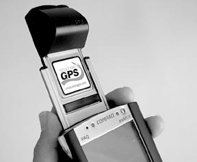
You can also buy just the GPS receiver-a nifty little plug-in module-for $399 or a bundle that includes the receiver, software, cables and a case for $599, the product combination we consider most practical for pilots.
TeleType has two versions of its GPS module. A ruggedized unit sells for $299 while a less expensive version costs $199. For the additional $100, we think the rugged receiver is the best choice. We had initialization problems with the cheaper unit. Both GPS modules have a remote antenna option to address cockpit antenna shadowing. We found the receiver worked we’ll without the remote, however.
You can also buy additional accessories such as cases, antenna boosters, serial cables, yoke mounts and various power cables and an external power pack. If this is beginning to sound like a computer geeks paradise, it is, to a degree. However, we found the TeleType Web site to be we’ll enough organized that you don’t have to be an IT manager for a Fortune 500 company to sort through it.
Fair warning: it takes minimal-but not advanced-computer literacy to get this device set-up and running. If youre a digital Luddite, get someone to help you or stick with a dedicated portable GPS and leave the PDAs to the geeks.
That TeleType is aimed at the computer literate is obvious from the moment you first open the box. Other than the hardware itself-not the PDA mind you but the GPS module, wiring and mounting hardware-all you get is a couple of CD-ROMs. One contains the software, the other the installation and operating manual.
There’s no paper manual at all. If you want one, you’ll have to print it out from the CD-ROM and its about 70 8 1/2 X 11 pages. We found the installation manual to be excruciatingly detailed, complete with screen shots to lead you step-by-step through the installation. Actually, because of some software revisions, we didnt use the CD-ROM provided but downloaded more recent software from TeleTypes FTP sources.
This installed more or less without a hitch onto our desktop computer and then onto the Compaq iPAQ we used as a test bed. For reasons not clear to us, the ActiveSync software-a Microsoft product-occasionally failed to work correctly. It simply wouldnt see the USB connection with the iPAQ.
Rebooting the desktop solved the problem but the lesson we draw from this is that like anything related to Windows, buyers should expect snags, major and minor. These can usually be sorted out but we would hardly call any of this technology seamless. Once loaded, the software appears as an icon in the program group. Tapping it fires up the program and away you go. Well, not quite. Did we mention you need to install the GPS?
For that, you’ll need the iPAQs extension sleeve, which provides a handy place to plug in PCMCIA modules that allow the palm top to work with the outside world. Teletypes GPS module plugs into that sleeve, along with an adapter that accounts for the fact that the GPS module is narrower than a standard PCMCIA slot. (If this sounds like a lash-up, it isn’t. The parts fit together in a logical way.)
Once the GPS module is inserted, the software automatically finds it and starts downloading satellite data. Except ours didnt. For reasons unknown, the first GPS module sent to us didnt work but TeleType replaced it with one that did. Remarkably, from a cold start, the GPS found itself in a matter of minutes, reflecting the fact that the GPS receiver itself stores relatively fresh ephemeris data. We found the GPS units performance to be excellent. Even on the office desktop, pointed away from the window, it easily tracked five satellites for solid position keeping.
In Flight
The TeleType system is quite easy to use because, frankly, there’s not much to it. Unlike dedicated GPS portables which tend to have multiple screens including HSIs and other displays, the TeleType software gets by with just one. You can, however, select either a full map view, or an arc view of what TeleType calls an HSI. Actually, its just a compass rose; no D-bar, as on Garmin portables.
Controls on the map display are similarly basic. Along the top, plus/minus signs permit quick zooming in and out, scaling up from a minimum of a few hundred feet to a maximum of 1000 miles. For flying, the scale is best left on 10 or 20 miles and for driving, 500 or 1000 feet works well.
At the smaller scales, TeleType represents the land background in light yellow, with roads in red and water in blue. Because of its strength as a road navigator, the TeleTypes roads and highways are numerous and we’ll labeled. Whether in aviation or road navigation, you can use a set of up/down/side arrows to pan the map.
We found that if not configured to declutter the screen detail, the iPAQ sometimes needed many seconds to think about multiple commands, such as scale changes and panning. On several occasions, it choked during these operations and had to be restarted. But unselecting the fix cursor option-which allows the map to scroll by a fixed center point-corrected this.
Along the bottom of the screen, TeleType presents four pull-down-actually pop-up menus that allow minimal customization and managing of the program. The file menu, for example, controls loading of maps-more on that later-while the view tab lets you set your own preferences with regard to cursor style, speed reminders, decluttering, units and language. When driving, the program can be set up to issue audible turning instructions, which is helpful in traffic.
Other menus lead to dialog boxes to monitor satellite status, specify waypoints and so forth. Unfortunately, unlike its competition in both the dedicated GPS field and in PDAs, the TeleType system lacks dedicated buttons for things like direct-to navigation, waypoint management, nearest airport, toggling between screens and so forth. In short, most of the stuff pilots expect as standard, the TeleType system doesnt have. But the company says the software is continually being improved and that these may be added.
We especially missed a direct-to key, the most fundamental function any navigator should be able to perform all but transparently. To do that on TeleType, you pop up the aviation menu, then select go direct from the choices. This yields a dialog box in which you use the PDAs tiny on-screen keyboard to key in the fix you want, then select the go-to button in the dialog.
The stylus-based keyboard is both bane and blessing. For as much as we despise tediously scrolling in identifiers via rocker buttons or even the concentric knobs on panel mounts, doing the same on a PDA keyboard requires the dexterity of a surgeon and the patience of Mother There’sa. Its not too awful in smooth air but in the bumps, its a stab fest.
And if you drop the all-important stylus, youre toast, for it will lodge in the remotest reaches of the seat tracks, accessible only at the next annual. We found ourselves wishing for a way to magnify the size of the keyboard by at least half again. Control Visions solution to this on the Anywhere Map software are large screen-based buttons, and these work well.
In general, the notion of touch-screen control for navigation is a good one and would probably work we’ll for something the size of an UPSAT MX-20. But in our view, a PDA screen is too small to make it work effectively in a cockpit.
Display, Land Nav
We thought TeleType uses the PDAs display effectively enough but not quite as we’ll as the Control Vision product does. Because of the data panel along the bottom edge of the display and the panning controls along the top, TeleTypes actual map is squarish and gives up a little area to the Anywhere Maps more vertical aspect.
Further, we found some data missing from the TeleType screen. The TeleTypes basic nav information includes altitude, bearing, distance, crosstrack and speed to the active waypoint. But we would happily give up altitude for a bearing/desired bearing pair and crosstrack for an ETE datafield.
Further, we would like to see standard aviation nomenclature for these items. Distance to go, for example, is stated as DG/mi rather than just the mileage next to the active waypoint. As with the better portables, we would prefer some way of customizing this information but the TeleType doesnt offer it. Were told that this capability will be added later.
Bottom line: You can navigate with this system but the data displayed is rudimentary by aviation standards. It also lacks such options as an all-numeric nav page, features weve come to expect as standard on aviation GPS of all ilks.
TeleTypes data includes airport and runway information, frequencies and other useful information and although it lacks approaches, it does have an extended runway centerline feature to assist with visual approaches.
In our view, the TeleTypes nav protocol reflects the companys broad specialty as a provider of all-purpose navigation software, not purpose-designed aviation systems, as with Garmin, Lowrance and Control Visions Anywhere Map. Obviously, a good land navigator can be useful but not if what you really want is an aviation GPS.
On the subject of land navigation, we think the TeleType system is quite good. As noted, the street maps are plentiful and we’ll detailed and there are provisions for keying in routes and looking up street addresses. TeleType also sells other map packages that will run on PDAs for marine and geo survey.
Worth noting is that using these maps requires some management and handling by the user. Because of the size of the map data and the limited storage capacity of PDAs, you cant load detailed maps of the entire world-or even the country-at one shot, although the aviation data can be loaded in its entirety.
The software has a map management function that allows you to export base maps from a desktop computer and load and unload what you need. This saves storage space on the PDA, of course, but it does require planning.
If youre off to Houston next month, for example, and forget to load the street maps you need, you’ll be out of luck, unless you have the foresight to carry the maps on a laptop, too. On the positive side, you can download software and map revisions from the Web.
Conclusion
Although we think the TeleType system is a credible product and find it logically designed and we’ll supported it is, alas, not yet quite to the standards weve become accustomed to in portable aviation GPS. By comparison to Garmins portables and the PDA-based Anywhere Map from Control Vision, the TeleType feature set is somewhat sparse. But its also cheaper than Anywhere Map so you get what you pay for. Both are undergoing constant refinement.
Whats missing is a more aviation-like operating protocol, with frequently used functions such as direct-to and nearest airport placed on the front burner, with quick access screen buttons. Further, we would really like to have the option of customizing the data fields to a dataset were more comfortable with.
And frankly, the more we use PDA-based GPS navigation, the more were hassled by the nuisance of it all; wiring, data plugs, special power packs, occasional lock-ups. Little of this is a factor with dedicated portables. Our advice is this: If you want a strong street navigator that can fill in for aviation, TeleType is worth a look. But for purely aviation use on a PDA, we think the Anywhere Map from Control Vision edges out TeleType in overall function and value. For convenience of use, dedicated portables beat them both hands down.
Contact – TeleType Co., 20 Park Plaza, Boston, MA 02116; 617-542-6220; www.teletype.com. Control Vision,Box 596, Pittsburg, KS 66762; 800-292-1160; www.controlvision.com.
Also With This Article
Click here to view “Checklist.”
Click here to view “New Accessories from ControlVision.”
Click here to view “Products and Prices Compared.”


